Chapter 5 The Arrival of the French
5.2 Emulating Brevedent's circumnavigation of French Island.
The Activity Log Book on the boat read as follows:
August 30th. People on board 4: Chris, Tristan, Hal and Phill
Full fuel tank at 80 litres, two spare jerry cans each holding 20 litres
Engine hours reading 133.7. Time: 0905 hours
All lifejackets, flares, registration papers located
Wind blowing moderately from the NNW, likely to increase as the day develops
High tide at Crib Point 1155 hours
Bouchier channel in the NNE (the danger spot or ‘hump' off Lang Lang Caravan Park), add 40 minutes to Crib Point time
Anticipated route:
Yaringa to YBY Buoy off Tortoise Head sand bank, steer approximately 180 degrees magnetic.
Tortoise Head bank to Elizabeth Isle. NE tip, steer approximately 85 degrees magnetic.
Between Schnapper Rock and Pelican Island, heading NE to Split Point.
Go through the gap at Stockyard Point. Find the buoys off the caravan park?
Head in a westerly direction to Yaringa, looking for complex sets of buoys.
Approximate revs 2000 to 2400 rpm. Estimated time four hours. Easy, hey!
Did we make it? We sure did!
At Yaringa 1235 hours engine reading 137.1 hrs.
It started with Chris as the coxswain, who deftly backed the boat out of its pen by alternatively backing, forwarding and spinning the steering wheel. Around the stern of the enormous catamaran, then immediately turning hard right and pointing down the first leg of the channel, with port and starboard markers. At this point in the tide the vessel was greatly exposed.
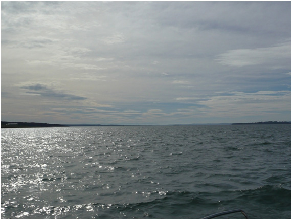
The weather had that silvery brittleness of sun, and there was a light ruffle of breeze on the water. Some seabirds were still stalking in the shallows, others were wheeling around in the air. All the fellows were grinning with excitement. Reaching the end of the cut, Chris turned right, called out ‘Hold on!' and zoomed up to 2400 revs. Up went the nose, the stern also lifted. The centre wave and vortex from the prop appeared enormous.
Past the ships at the wharves of Blue Steel, Esso and Stony Point, down to the Yellow Black Yellow buoy at the western tip of the Tortoise Head sandbank with a GPS reference of South 38.17 and East 145.18 minutes. Both the guys had been in the cabin, with Hal and Phill in the open cockpit drinking coffee, having a sandwich and chatting.
Now Hal took over the steering and the fellows engaged in a general discussion about all the difficulties the early explorers encountered. Looking all around at the YBY buoy, the Port appears huge. The distant hills, in all directions of the compass, the apparent diverging of the Port to the right as well as to the left. High tide, low tide-what a difference it makes in this Port, particularly with rain or haze or glare. In the days of those explorers much work consisted of muscle power, with back-breaking rowing or hauling on ropes and anchors, chopping scrub and trees, planting crops. They battled fierce winds, ropes and canvas that snapped and tore apart.
They always ran the risk of going hungry, trying to shoot birds, trying to catch fish. There was the constant problem of finding water and getting it back to the camp. Sometimes they were cold and wet, at other times sunburnt. They knew the fear of the unknown, and it took courage to start a settlement from scratch, defending the area with a Fort, such as the token Fort Dumeresq at the headland overlooking Seal Rocks, with a flag pole and two ineffective ship's guns. Was Hanns creek any good? How come Corinella failed? Could the crews get back safely to Port Jackson?
During the discussion all the fellows began to feel it was all too hard, and tough. Would they have been able to take it?
From the left: east tip of Elizabeth Island; centre; marker buoy with Schnapper Island. On the right: Settlement Point.
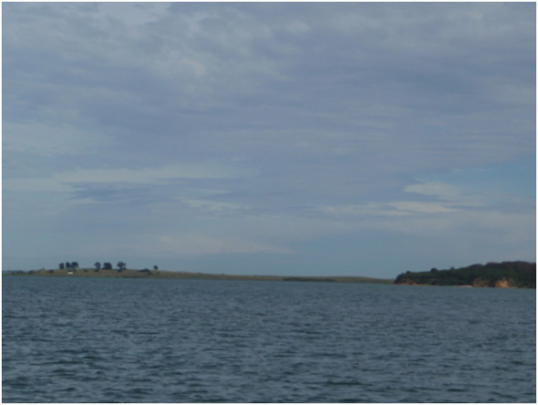
Looking west to Elizabeth Island. The headland on the right is part of French Island; the dark strip in the middle is part of French Island. This offered easy anchorage in the channel for the Lady Nelson.
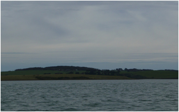
The big hill on French Island protects from westerlies the channel visible on the right-hand side
Sometimes the conversation produced wildly speculative comments, with lots of rubbishing, all in good fun. Of French Island, they passed the ex-prison-farm buildings. The gap between Split Point and Stockyard Point suddenly became apparent. Until then it had merged into the background hills and large area of silvery glaring water. Even the Telstra tower was evident some kilometres to the direct north.
The guys were commanded to go forward and sit in the bow to locate the next marker buoys and also constantly look for the bottom. The wind picked up and the water became quite bumpy. The boat started to ship lots of water over the bow at this stage and both guys got drenched. Tristan gave up and went to the cock pit, Chris grimly stayed on but even he had to give up and go into the cabin, and try to squeeze out water and get warm.
This area of the map shows several channels running approximately north, just like the fingers of a hand without the thumb. From the Lang Lang jetty on the east to Palmer Point in the west on French Island, there are extensive mudflats without supporting channels. This is the area known as the hump.
As always in life, the unexpected can happen. At the crucial point in entering the hump area, the GPS lost its satellite fix. The GPS was affixed to a moving map that clearly identified where all the channels were. All on board felt immediate concern. At least the depth sounder was still working: progression from 2.0 metres to 1.2 metres to under a metre happened quickly. Where were the marker buoys?
Distances over water can become magnified or blurred. Both seem to have occurred here. The crew eventually found and negotiated the marker buoys. They felt great relief, as they were at the top of the tide, and it was the highest tide in the 24-hour cycle. There was no margin for error.
Midshipman Brevedent and the French crew may have spent a night on Palmer Point, because the sandy spit looks clean and inviting, whereas the rest of the shore looks mangrovey and smelly-probably full of mosquitoes as well.
The return to Yaringa was rather an anti-climax. Both the young guys were letting off steam by raising their arms horizontally, grasping the cockpit sail cover struts and doing chin ups. Now everyone was hungry and soon polished off their own packets of sandwiches. Phill and Hal really enjoyed the strong coffee.
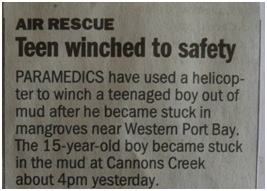
Our Port areas can be dangerous: a news item from the Age, 2008.
Previous Chapter | Chapter Selection | Next Chapter | Download Chapter