Chapter 2 Under Weigh
2.6 Diary of Geo. Bass:
Part of my official journal for Governor Hunter.
I have named the harbour from its relative situation to every other known harbour on the coast, Western Port. It is a large sheet of water branching out into two arms, which end in wide flats of several miles in extent. It was not until we had been here some days that we found it to be formed by an island, and to have two outlets to the sea. An eastern, and a western passage.
We went in and intend going out by the former, which is winding and narrow. I walked along the west side of the island at a time when it was blowing fresh from the SE the weather would not allow us to go through the western passage. A heavy surf going upon the shore, so that I must have seen everything that broke, but saw no breakers except those I have marked in the sketch, which I am sorry to say, after all the vexation I have had with it, is but very imperfect.
The general rise of tide is from 10 to 14 feet. It flows on the full and change days about half past twelve. The soundings are frequently irregular, which is perhaps occasioned by the cross-setting of the tide out of the two arms into the two outlets. And by the softness of the bottom, which is chiefly mud with a little sand; mud abounds so much that the greater part of the points are not approachable except towards the top of high water. Then at the risk of having your boat left until the next tide, for the mud runs out far and flat, and so soft that there is no walking the boat over it.
There are indeed in some places sand shoals, and those tolerably hard, but even they tail off in mud. I have not in the sketch attempted to lay down all the shoals, except in that place where any vessel would be the most likely to anchor, or their exact direction. Accuracy, independent of its being altogether out of my reach, would, I believe, to anyone be the labour of months.
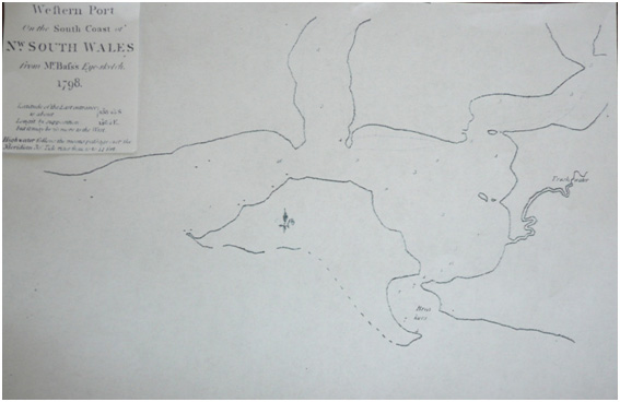
Sketch of Western Port by George Bass in 1798, drawn from observation only. SLV.
The land round Western Port is low but hilly, the hills rising as they recede, which gives it a pleasing appearance. Upon the borders of the harbour it is in general low and level. In the different places I landed I found the soil almost uniformly the same all round-a light brown mould free from sand, and the lowest lying grounds a kind of peaty earth. There are many hundred acres of such sort of ground. The grass and ferns grow luxuriantly, and yet it is but thinly and lightly timbered. The gum-tree, she and swamp oaks, are the most common trees.
The island is but barren. Starved shrubs grow upon the higher land, and the lower is nothing better than sandy brushes, at this time dried up. We had great difficulty in finding good water, and even that which was brackish was very scarce. There is, however, every appearance of an unusual drought in the country.
The head of the winding creek on the East Side, which I have marked with Fresh Water in the sketch, was the only place we could procure it free from a brackish taste. At half tide there is water enough over the shoals for the largest boat, and within the creek there is at all times a sufficient depth. We sculled up the creek, as apart from the mouth, the actual channel width would not allow us to use our oars to row.
There seem to be few natives about this place. We only saw four, and that the day after we came in, but they were so shy we could not get near them. There are paths and other marks of them in several places, but none very recent. The want of water has perhaps driven them further back upon the higher lands.
We saw a few of the brush kangaroo, the wallabah, but no other kind. Swans may be seen here, hundreds in a flight, and ducks, a small but excellent kind fly in thousands. There is an abundance of most kinds of wild fowl.
The eastern entrance of this place has so conspicuous an appearance by the gap it makes in the land that it cannot fail of being known by anyone coming from the eastward.
The point of the island, which is a high cape, like a snapper's head, forms an island. The entrance appears like a passage between it and the main. The latitude of it will be found to be somewhere about 38 degrees 25 minutes.
Executing my secret orders.
The western arm that heads northwards past a sandy point has two large inlets that look unaffected by low tides. Past the northern most one I detected an area where several small creeks entered the harbour. I decided to follow an old path along one for approximately three miles. I discontinued exploring along the creek when it became impossible to chop our way through any further using our cutlasses.
Immediately on our right was a small hill that I had detected from the lower reaches of the harbour. It could act as a fort location because the view looking SSE would cover the main sheet of water available for ship manoeuvring or anchoring, upon entry from the ocean. Looking NNE to ENE would complement available harbouring, to the Sandy Point. Water in the western entrance up to the Sandy Point was very dangerous with shoals and sandbanks. No ship's Captain would ever anchor there. At Tortoise Head a perfect fort could be built, but it could be encircled and cut off. This hill could be a safe small fort, that could not be encircled and attacked.
Somewhere along the fresh water section of the creek it would be possible to hide longboats and small schooners.
Previous Chapter | Chapter Selection | Next Chapter | Download Chapter