Chapter 1 Westernport
1.4 Film Mutiny on the Bounty; navigation aids.
School was over for the day. The guys were staying for an early dinner while watching a movie and were going to learn a little about navigation.
This movie was a little different from the movie about Captain Cook's voyages they had watched weeks ago. If Captain Cook had problems in Tahiti, so did Captain Bligh with Fletcher Christian. Christian finally landing on Pitcairn Island.
"I wouldn't have burnt the ship. What if they ran out of food! Anyway how could they escape if they were discovered?" Chris wondered.
"Yep, I agree. Anyway, how did they find the Island in the middle of the Pacific ocean?" What a good question from Tristan.
Other questions followed, with Phill trying to answer them all. Then they began a brief study of navigation. On the dining-room table Phill had propped up a small white board, and spread out two large maps. One was a naval chart of Westernport, the other was an aeronautical map of Victoria.
On the white board he had written: the Earth's shape, gravity, tides, latitude and longitude, sextant and compass. Whew! a bit over the top.
"Okay guys, let's start with the shape of the Earth. You know it's not flat and you can't fall of the edge."
"Course not, Phill, it's shaped like that globe you have over there on the sideboard." Tristan's sharp eyes said it all.
"Chris, over to you. What's gravity?"
"Throw something in the air and it is pulled back to Earth. Unless you have a space rocket that has big enough engines to force it out of the Earth's gravitational pull."
"Good stuff, you guys are really switched on. Tristan, how do tides work?"
"Well ..."
"Chris?"
"Well ..." Much laughter from everyone.
"Guys, a simple theory is that on opposite sides of the Earth, two gigantic waves are present, and they move around the Earth directly opposite each other, even while the Earth itself is rotating. The waves are not tall, it's that they cause an enormous volume of water to move. Gravity prevents the waves from taking off into space. So maybe if it's roughly high tide in Melbourne, it is roughly high tide in the middle of the Atlantic ocean, on the other side of the world. Low tides would be experienced in other places."
"As the Earth rotates the moon and to a lesser extent the sun pull at the water. High tides suck up the water, leaving lower water or low tides in other places. Here in the Melbourne area, we experience two high and two low tides in 24-hour cycles. Most places in the world experiences tide changes approximately every six hours. The tides and heights are mathematically predictable many years in advance, and get later by approximately one hour a day."
Then the guys looked at a printout of tide predictions from the Bureau of Meteorology. It looked like the following table.
Table 1.1 Bureau of Meteorology (Melbourne) Tide Predictions for 1 May 2008
|
Thursday 1/05/08 |
Friday 2/05/08 |
Saturday 3/05/08 |
|||
|
Time |
Height |
Time |
Height |
Time |
Height |
|
0100 hrs |
1.03* |
0146 hrs |
0.99 |
0245 hrs |
0.92 |
|
0719 hrs |
2.28 |
0823 hrs |
2.26 |
0943 hrs |
2.32 |
|
1303 hrs |
0.77 |
1358 hrs |
0.92 |
1508 hrs |
1.07 |
|
2005 hrs |
2.50 |
2056 hrs |
2.44 |
2156 hrs |
2.40 |
"Well guys, now for the interesting parts. First, the compass. You both have a hand compass. Chris, look through yours and line it up with end of Tortoise Head. Tristan, line yours up with Barrallier Island over there. Then tell me the reading on the dial. These days it is also called a bearing or sight. What do you get?"
Tristan: "About 75 degrees."
Chris: "About 140 degrees.'
"Good. If you look at the drawing of a compass rose, pretend you are standing in the middle looking outwards . Tristan, your bearing is roughly East North East. Your bearing, Chris, is roughly South East. From now on when you hear the weather report or look at the wind direction in the trees you will understand the direction it is from."
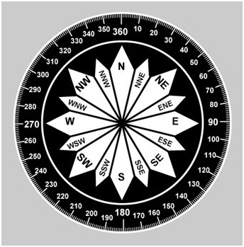
A compass and wind-direction rose
"The sun always rises in the east. The sun always sets in the west. If it doesn't our world as we know it is finished."
"If you stand with your right side to the east, you can always point to areas of the compass. For example if the wind was coming from 200 degrees, it would be coming from the south-south-west."
"If the wind was coming from 40 to 50 degrees, it would be coming from the north-east."
"Still with me, guys?"
"Hmm," mumbled Tristan. "Pass over the biscuits please!"
No word from Chris. Was he bored or bedazzled?
"See that drawing in pink? Now the explanation gets tough."
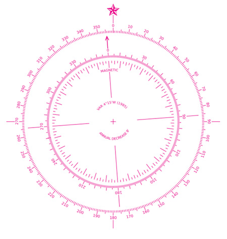
A compass showing the difference between true north and magnetic north
"The external ring, at 0 degrees, shows true north. Whenever you see a map, it is always drawn to show true north. The internal ring in this representation is pointing to 356 degrees magnetic north."
"A compass always points to magnetic north. A few degrees away from true north, a gigantic magnetic area exists. All seafarers, pilots and bushwalkers have a compass that points to magnetic north."
"Bit heavy, hey guys? Never mind, when we practise navigation it will all become as clear as mud. If you are going, say, from Tyabb to the northern end of Flinders Island, draw on that map a straight line from Tyabb to Flinders Island, in Bass Strait."
"That is approximately 125 degrees with a map that is accurately drawn to true north. Now subtract 12 degrees for magnetic variance in our area. The magnetic heading becomes 113 degrees."
"You can now swim, fly a plane or walk to Flinders Island using your magnetic compass and you will not get lost!"
"Boys, how about having a break, and trying these fresh cakes I have baked?" suggested Nan.
Like wolves around a feed the guys attacked the cakes.
After the break, Phill picked up the thread.
"Okay, guys, nearly over. I suppose both of you have homework to do tonight."
Long groans from the guys.
"Latitude and longitude. This is simply a scale, on all the border of a map. When you draw horizontal and vertical lines to intersect at a place, you can read the lat and long. This house at Tyabb, for example, is 38 degrees 15 minutes 42.87 seconds South (of the Equator) and 145 degrees 11 minutes 30.06 seconds East of the prime meridian. Easy, hey! Don't give it any more thought, because we will practise it. Anyway, if you use Google Earth you can identify any position very easily."
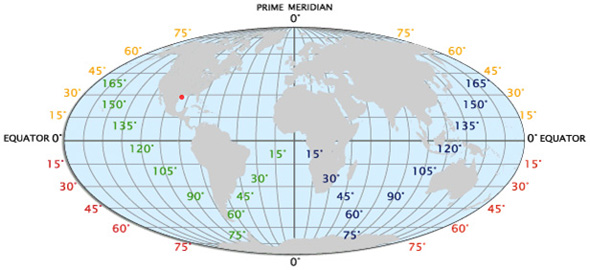
The globe, illustrating Latitude and Longitude
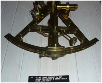
A sextant, used to measure the angular distance between two objects . LDMM.
"Well, guys this is my sextant. It is made of very good quality plastic, and cost about $500. Sextants were and are still is used at midday to sight the sun and the horizon through mirrors, and read on the markings the angle that separates them. The angle is then used with mathematical tables to establish your position on the globe. Cook and Bligh, like all mariners of their time, used a sextant in navigation.
" I have one so we can practise it if you want to. Maybe you would prefer to use your father's global positioning system. The GPS will simply print out your position in degrees and minutes, when it has picked up several satellites."
The guys were starting to go glassy-eyed. Time to call it a day.
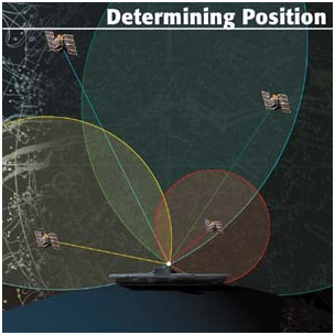
A global positioning system (GPS) at work
Previous Chapter | Chapter Selection | Next Chapter | Download Chapter